Impact of technology on modern land surveying techniques
The Government and businesses invest heavily in infrastructure to scale and expand their infrastructure portfolio and provide for development. However, before making a real estate purchase, extensive land surveys are conducted and are an integral part of an infrastructure development plan. Land surveying has evolved rapidly with technology and eliminated the most primitive and persistent issues which existed almost thirty-five years ago.
How has technology transformed land surveying techniques?
The previously available tools to conduct land surveys produced results which were adequate for the time and prevalent land surveying requirements. However, with the new age developments, the role of land surveying assumed a critical role to determine smooth infrastructure development.
The Plane Table survey was initially devised to perform land surveys. It lost its charm to Theodolite which was updated to Electronic Theodolite, which evolved into Total Station. New technologies emerged with a focus on developing smarter solutions to reduce the processing time and increase effectiveness. The rise to the latest and most advanced tool in the history of land surveying – Drones, has simplified the entire process and produced great results.
Technology has empowered the people dedicated to infrastructure development to use the available land wisely owing to the following benefits:
Accuracy: Modern instruments used by land surveyors have an accuracy of distance measurements by +/- (2mm + 2 ppm) x d. It is exceedingly accurate when compared to the results produced by the tools developed a decade ago. For a fundamental and complex process such as land surveying, accurate results have revolutionized the entire process.
Scope/Portfolio: Previously, land surveying techniques were limited in scope as the technologies themselves. Fast forward to now, these methods have evolved extensively and are no longer limited to measuring land. They are now being used to survey the sea, and airspace to discover new infrastructure development opportunities and revolutionize land use.
Speed: One of the areas which have been primarily impacted by the evolution of land surveying technologies is the speed of the process. With advanced technology, accurate results are presented in a few hours. Drones don’t require much human effort and are designed and developed to deliver faster results.
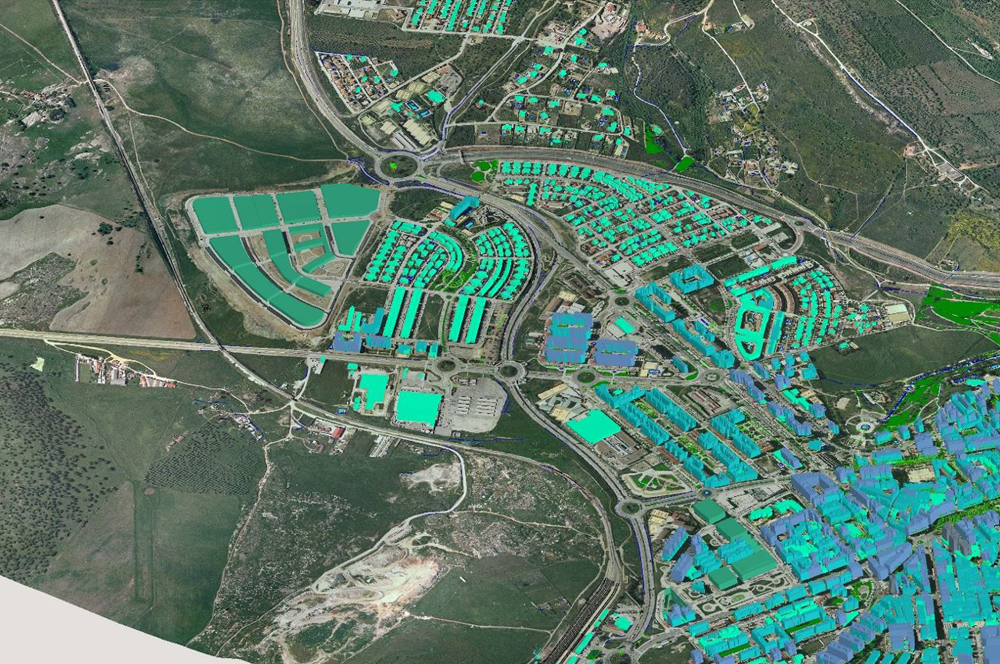
Infrastructure Possibilities: Land surveys are the core of infrastructure development. Smart cities, futuristic transportation, impressively designed buildings and much more are a result of the technological evolution in land surveys. Technologies like GPS and DGPS have brought about transparency in the infrastructure domain with its satellite mapping capabilities. Integration of high-level tech as such has been the main reason for our imagination coming true in the field of infrastructure.
New age land surveys – powered by technology
With population explosion, sturdy and reliable infrastructure is one of the needs of the hour. It is imperative to perform land planning amid limited space available to build the level of settlements suitable to man. The evolution of artificial intelligence and automation has given rise to multiple possibilities, which earlier seemed impossible.
Conflicts have been eliminated due to advanced development. As a civilization, we have evolved in the past two decades and made more effective use of our land resources for better infrastructure and green spaces. The smart-cities, metro-cities, roadways, railways and any other form of architecture that we witness today is a testament of accurate and efficient land surveying powered by technology. If our generation is to build the infrastructure of the 21st century, land surveying will play a major role in achieving this goal. Technology integrated with land surveying has been instrumental in making it all possible.
The road ahead
There is no denying that Artificial Intelligence and Automation will bring better products and techniques to ease the operations of a surveyor. The road ahead predicts cloud-based data storage as the norm, with UAVs playing a significant role and data made available instantly. The latest evolution of technology has impacted the design and functions of modern land surveying techniques in a massive way, and fresh impact is yet to come.